Draft Masterplan
Click on the thumbnail below to expand and view the Draft Masterplan document.
North West City Park Draft MasterplanAnchor Zones
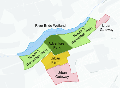
The park is divided into five “Anchor Zones”.
The Park’s Anchors are the primary elements that define its spatial organisation, identity, and range of experiences. Each Anchor represents a distinct landscape character zone with a specific role within the wider masterplan, combining recreation, ecology, movement, and community use.
- Urban Gateways at Kilmore Heights & Fairhill
- Urban Farm
- Nature Recreation & Trails
- Adventure Park
- River Bride Wetlands
Anchors provide a strong framework for delivering the masterplan, dividing the overall landscape into coherent, manageable zones that can be developed, activated, and enhanced over time.
Urban Gateways at Kilmore Heights & Fairhill
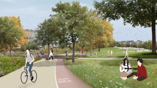
The Urban Gateway at Kilmore Heights and Fairhill form the principal civic arrival spaces to the North West City Park, creating a clear and welcoming transition from the surrounding urban neighbourhoods into the wider recreational landscape.
The Kilmore Heights entrance establishes a lively and accessible neighbourhood park, blending social life, active recreation and landscape into a cohesive and high-quality entry experience.
Walkways, layered public spaces, and strong visual connections invite exploration and support everyday use. Plazas, event lawns, café terraces, and structures provide places for gathering, rest, and community activities, while nature-based play, cycling and skate features, and compact sport courts introduce energy and movement into the core of the park. It will accommodate full-size sports fields, courts, and training areas alongside fitness routes, cycling circuits, and walking loops.
The Urban Gateway at Fairhill forms the primary eastern entrance to the park, providing a clear and welcoming connection between the Fairhill neighbourhood and the wider landscape beyond. More compact and intimate in character than the Kilmore Heights gateway, it is conceived as a neighbourhood-focused arrival space that blends natural qualities with everyday recreation and social use. Its layout brings together small-scale activity areas, social spaces, and shared movement routes within an accessible and familiar landscape setting.
Along the Fairhill urban edge, the gateway functions as a neighbourhood park, defined by a small entrance square, seating steps, parking, and clear wayfinding. From this point, walking and cycling routes extend seamlessly into the park’s broader east–west and northbound networks. Amenity lawns, allotments, seating areas, and a small landscape square support informal play, rest, and daily neighbourhood use.
Urban Farm
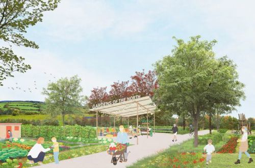
The Urban Farm – Gardens of the North West is a distinctive anchor zone rooted in the agricultural heritage of Cork’s Northside, with a strong emphasis on community involvement and long-term stewardship.
Centrally located and accessed from Nash’s Boreen and a future road connection, the farm is structured as a layered productive landscape. Gardens and community growing areas are clustered around the farm centre, gradually transitioning into orchards, flower meadows, and open ecological habitats toward the park edges. These edges are designed to extend into and reinforce wider biodiversity corridors, strengthening ecological connectivity across the park and its surrounding landscape network.
The zone is designed as an inclusive and welcoming environment for all ages, combining community growing, hands on education, biodiversity enhancement, and small scale artisan food production. A visiting farm with small animals adds a family friendly dimension, supported by circular systems such as composting and biodigesters. A transport and mobility hub at the North West entrance, incorporating car, bus, and bicycle facilities, ensures accessible and sustainable access for visitors, school groups, volunteers, and farm operations.
Adventure Park
The Adventure Park is a major recreational anchor at the centre of the North West City Park, designed to attract both local users and visitors from across Cork city, county and beyond. Conceived as an immersive woodland landscape, the park transforms the natural slopes into an active and engaging environment where the land itself becomes the playground.
The anchor is located in an area of the site fragmented by the road corridor. The introduction of a land bridge repairs this separation, reconnecting both sides physically while sustaining green systems, ecological flow, and wildlife mobility.
Inspired by trail-based landscapes, the Adventure Park offers a range of cycling and adventure experiences for all abilities—supported by resting points, viewing areas, and informal woodland “rooms” that allow moments of pause. To the south of the road corridor, an accessible hub provides bike rental, food, seating, and amenities. From here, the land bridge spans the corridor, linking the hub safely to the sloped northern landscape where the main trail and activity network descends toward the River Bride Wetland.
Within the forested pockets, a series of playful, nature-based structures encourage climbing, balancing, and imaginative exploration. A zipline launches from the elevated northern ridge, carrying visitors above the treetops and offering sweeping views across the wetland valley.
Within the woodland, a treetop adventure play zone introduces rope bridges, climbing elements, and canopy walkways, creating a layered and immersive adventure experience that complements the trail network and encourages play and exploration.
Nature Recreation & Trails
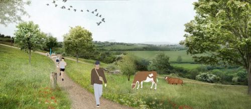
The Nature Recreation & Trails West anchor area occupies the sloped hillside between the road infrastructure corridor to the south and the River Bride Wetland to the north. As the park’s most nature-led recreational zone, it is defined by open meadows, scrub mosaics, hedgerow corridors, woodland edges and a network of immersive trails. The hillside topography, natural vegetation patterns, and expansive valley views create a setting that prioritises a nature-first approach to recreation.
The area supports low impact activities that work with the existing terrain, including walking, running, nature play, cross country use and informal exploration. Seasonal razing, ecological enhancement and meadow management shape a dynamic landscape. Portions of the active travel corridor run along the southern edge, offering panoramic views and a strong east–west connection.
Cultural heritage is a key layer in this landscape. The Historic Monk’s Trail—once linking Teampall na gCillíní near the River Bride with the medieval abbey near Gillabbey Rock—is reinterpreted as a marked heritage path with wayfinding and interpretive signage.
Along the southern boundary, a fenced dog park and a pitch and putt course are integrated where accessibility and visibility naturally support more structured but still low impact uses. The Nature Recreation & Trails East anchor area occupies the eastern hillside between Nash’s Boreen to the south and the River Bride Wetland to the north, with the road corridor and active travel route crossing its mid-slope. This landscape-led area is characterised by open meadows, scrub mosaics, hedgerow corridors, mature trees, and woodland edges, interwoven with a network of immersive trails that follow the natural contours of the hillside.
The Land Bridge, a key ecological and recreational feature, spans the road corridor to reconnect the northern and southern slopes. It provides safe passage for pedestrians, cyclists, and wildlife, while visually unifying the fragmented hillside.
Cultural heritage enriches the area through the Croppy Boy Way, a historical walking route preserved within the trail network. Interpretation elements highlight its connection to local folklore, embedding cultural identity within the natural environment.
Flexible, low-impact activities such as walking, running, nature play, grazing, and ecological engagement define the character of this area, encouraging informal use and exploration.
River Bride Wetland
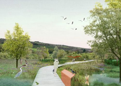
The River Bride Wetland forms the ecological heart of the park’s northern landscape and is one of its most defining natural features. The river shapes local hydrology, supports biodiversity, manages floodwaters, and gives the valley its distinctive spatial character. By restoring natural river processes and reconnecting the river to its floodplain, the landscape becomes a dynamic and resilient ecosystem strengthening climate adaptation while enhancing the park’s ecological and experiential value.
The wetland also holds strong cultural significance. Local memories recall children walking down to the River Bride to play, meet friends, and fish along its banks. These stories inform a renewed vision for the river corridor as a place that supports nature-based recreation, environmental learning, and accessible movement, while carefully protecting sensitive habitats.
Along the valley floor, the wetland unfolds as a rich mosaic of riparian woodland, wet grasslands, marshy hollows, and seasonal ponds. Boardwalks, raised paths, and soft trails allow visitors to move through and experience this landscape at close range, while minimising disturbance. Bird hides, viewing platforms, and interpretive features offer opportunities to observe wildlife and understand the river’s seasonal patterns.
There is the opportunity to introduce explorative and nature recreation: water play with shallow rills, hand pumps, stepping stones, and interactive channels that encourage curiosity and sensory engagement. These activities are intentionally located outside the active stream zone, positioned instead within a more managed and designed landscape setting. This approach ensures that play remains immersive and nature‑connected while protecting sensitive habitats, maintaining water quality, and preventing disturbance to wildlife.